building bim laser scan

Mobile Mapping Surveys for Mines and Quarries

In recent times, mobile mapping has emerged as one of the most significant geospatial technologies available. Mobile mapping enables us to capture essential data and survey features, which would be hard to collect with more traditional forms of surveying, and at a very rapid rate. Areas thought previously inaccessible can be surveyed and mapped with efficiency and concisely by our mobile mapping team. Since its emergence, it has changed the way that mine sites can be measured, visualised, assessed and presented. 

How We Use Mobile Mapping

Merrett Survey can provide rapid mobile laser scanning surveys in virtually any location. Mobile laser mapping systems can be mounted on any mobile vehicle/vessel for rapid mapping of quarries, access roads, railways, tailings dams and opencast workings. We collect millions of accurate survey points. The ‘point cloud’ data this method produces can be used for a wide variety of applications, including calculating accurate stockpile volumes, updating progress in open pits and even overburden stripping operations.

All of the data collected through mobile mapping is captured to survey grade precision. What’s more, the use of this technique means that man-hours are reduced and health and safety is improved through surveying features from a safe distance and keeping survey staff ‘in vehicle’.

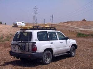
Here you can see Vehicle mounted laser scanner for rapid survey of stockpiles, opencast mines, access roads and much more.


Vehicle mounted laser scanner - mobile mapping Morocco


Mobile Mapping Case Studies

The Merrett Mining Survey team has been measuring the volumes of stockpiles of phosphate at opencast operations in Morocco on a monthly basis to ensure a rapid ‘snapshot’ calculation of the mineral volumes for audit purposes. The mine sites were separated by many miles across a large area and by using mobile lidar attached to a 4WD we were able to drive around the conveyor loaded stockpiles at each site, then move on to the next location.

Indoor stockpiles were also measured using laser scanning methods, sometimes using a bespoke vehicle mounted ‘arm’ that was projected into all storage hangar openings, and sometimes using a tripod mounted instrument when this was not possible.

Contact us to discuss how 3D mobile mapping can help your business. Our mobile mapping team will happily discuss how the technology can impact your operations. 

Ready To Get Started?

Get in touch with one of our specialists today

Contact Us

Find Your Bespoke Mobile Mapping Solution Today

Contact One of Our Specialists

Contact
Contact Us