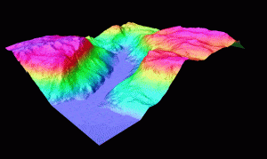
airborne laser scanning project in algeria

Lidar and Aerial Mapping

Merrett Survey can provide airborne lidar surveys worldwide for your mining site, mineral licence area or for your infrastructure route – whether rail, road, long distance conveyor, pipeline transport or powerlines.

How Lidar Technology Works & The Benefits

Lidar technology can provide so many advantages for related mine survey work. Lidar is Light Detection And Ranging (just as Radar is Radio Detection And Ranging), using laser beams to measure distances from the manned or UAV survey aircraft to the ground. The IMU (Inertial Measurement Unit) measures the aircraft’s roll, pitch and yaw and thus corrects the direction of the laser beam producing highly accurate coordinates and heights for the surveyed points.

Here you can see 3D data surveyed by airborne lidar for mine development site in Greenland. The data is Coloured by height.

airborne lidar survey dtm

More Benefits

By firing up to 500,000 points per second, the survey aircraft conducts mapping on the terrain beneath with great rapidity and generate a ‘point cloud’ of data, recording the terrain shape in high detail. DTMs and DEMs are produced modelling the ground and the top of foliage in forested areas.

Another advantage of Lidar is that it can map the ground surface beneath forest cover to obtain accurate DTMs of your mining prospect as seen here.

lidar pentration through rain forest in equatorial guinea

Terrestrial Lidar

Whilst the scanning technology used in tripod mounted scanners, placed on the ground is the same as that used in the aircraft, our industry tends to use the expression ‘laser scanning’ for the work on the ground, and ‘lidar’ for that used in the air. For our ground based scanning services, please refer to our laser scanning page, or our dedicated laser scanning website which covers our work across multiple industries.

If you have any question for us, relating to our Lidar surveys and wider Lidar services, please contact us. A member of our Mining Surveys team will happily discuss how the application of lidar technology could impact your project and output.


Ready To Get Started?

Get in touch with one of our specialists today

Contact Us

Find Your Bespoke Lidar Survey Solution Today

Contact Our Specialist Team

Contact
Contact Us