satellite remote mapping

Remote Sensing

Mapping using satellite imagery is becoming more detailed, more up to date, and more accurate. Now, the technology is a serious potential replacement of fixed wing aircraft aerial surveys.

If you have a mining project you wish to start or expand and require an up to date survey, digital terrain model (DTM), map of the mine site and it’s surroundings, then we can provide the fixed wing photogrammetry with UAV drone and lidar options. We can also provide the alternative – satellite based imagery and mapping through remote sensing.

The Merrett Mining Surveys team will provide the full details of achievable accuracies and costs, so you can decide the most effective route forward for your project.

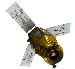
Here you can see Kompsat 3 a satellite – with 50 cm resolution and has a revisit time of only 3.5 days.


remote sensing device for high resolution satellite imagery

In addition, the advent of mini-sats is also a technology we are watching. The low cost of these systems (constellations of multiple remote sensing satellites) enable full coverage of the earth’s surface with rapid repeat survey.

This will include daily coverage. The old pattern of having to use imagery that is 6 months or a year out of date will soon end and we are in position to bring you the very latest remote sensing technology to benefit your mine or quarry operations.

If you would like to learn more about our the remote sensing technologies available to our mining surveyors or would like to enquire about our related services, please contact us today.

Ready To Get Started?

Get in touch with one of our specialists today

Contact Us

Find Bespoke Remote Sensing Services Today

Contact Our Specialist Team

Contact
Contact Us